|
AFTrack
is the display for your GPS mouse and activates the world of
hiking, biking, sailing, geocaching or more for your phone. The program
handles tracking with smart and fixed logging features. It sends
reports via GPRS or SMS. It receives SMS position messages and show it
as a waypoint. It exports and imports waypoints and routes und uses online and offline maps. And more.
Features:
- Six views to the GPS data - position, goto, track
summary,
map, altitude profile, satellite
- Big diplay
- Tracking the current way
- Export tracks (PCX, IGC with security record
(registered at http://www.onlinecontest.org/),
KML viewable
with Google Earth or GPX)
- Import routes from routes or tracks (PCX, GPX, KML,
OVL)
- Degree or UTM format
- Edit position in selected output format
- Import JPG, GIF, PNG, BMP, TIFF, GeoTiff or BSB as
map - BMP, TIFF, GeoTiff and BSB size can be larger then phone memory
- Using tile collections of online maps for offline use (OSZ-Format).
- Calibrate maps with various types
- Automatic calibration from different cal file formats
- Automatic map selection from the map storage
- Waypoint group to organize the waypoints
- Save current position as waypoint
- GoTo a waypoint
- Import waypoints (PCX, Geocache LOC, GPX)
- Export waypoints (PCX, KML)
- Using extra text files for waypoint description (e.g.
details of a geocache, groundspeak:long_description is supported)
- Make route from a track
- Makes way points to area
- Reverse routes
- Alarm on reached POIs, anchor alarm
- GPRS position sending
- SMS position sending
- SMS position receiving
- Reset GPS from SIRF to NMEA mode
- Automatic reconnection to GPS if connection lost
- Filter the altitude and speed values with a Kalman
filter
- Logging the NMEA sentences
- Long time tracking
- Support for GLONASS satellites (extern gps only)
Note:
This application
requires an external Bluetooth GPS device or a plugin for the internal gps.
Installation
Use the PC Suite to transfer and install this software.
Make
sure to switch your Application Manager settings to 'All' for Software
installation.
|
| |
Application
structure
| Main View - a
little bit different in 2nd generation version |
Track
 |
Goto
 |
Map
 |
Big View
 |
Satellites
 |
| Data
Collection |
| Tracks |
Way point groups |
Way points |
Routes |
Maps |
| Settings |
| GPS |
Display |
SMS Report |
HTTP Report |
IGC Export |
|
| |
|

|
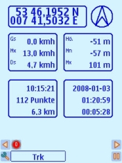
Main
window
The main view
shows you the standard values for navigation. Additional you'll
find some indicators on the bottom: satellites, connected to
GPS,
2D or 3D
view and logging on.
 -
no satellites -
no satellites
 - 2D - 2D
 - 3D - 3D
 -
EGNOS/WAAS -
EGNOS/WAAS
In the 3rd edition of the os the view is added with
track information.
|
|
|
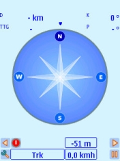
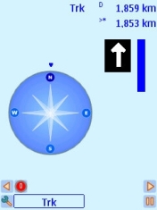
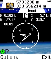
Other Views in main window
GoTo
In this view a hold position is used to show you the way
to
this point.
D = distance
B = bearing
S = speed
C = course
TimeToGo has no label.
The outer circle represents the course angle the inner triangle the
bearing.
TTG is build from the average speed of the current
track. If
this is zero the current speed is used.
|

|
Routing
This view is alternate to the GoTo view. It is shown
when
routing is on. Some useful values are available:
Route name
Distance
Direction to the next point (big arrow)
Direction of the next point
Distance to the next point
|

|
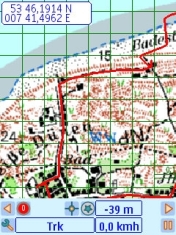
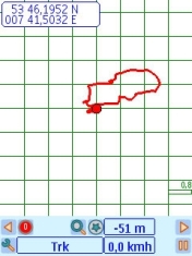
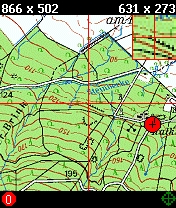
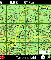
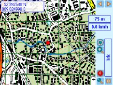
Map
The map view shows the current track or route or both. A
red
sign shows the position - when running as arrow of your direction.
The map can have different meaning. The '*' key switches
between position, track, route or map centered. When on a track always
the
position is in the center.
See this sign
 position
center position
center
 track
center track
center
 route
center route
center
 map
center map
center
Use the up and down key for scaling.
Press '#' for a change of the key meaning.
Now you can move the map. But can't go left or right to the next view.
A background map can selected from the map list -
calibrate
map first. When back from the list the map view and track or route are
set to the map dimensions.
In 3rd generation hardware you can leave the map list
with
'back' to get a single map or via the menu 'auto map' (shortcut '0') to
activate the automatic selection of map at your view point.
|

|
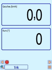
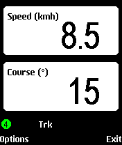
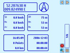
Trip
The statistical view. The values are
- current speed
- max. speed
- average speed
- current altitude
- min. altitude
- max. altitude
- starting time
- duration
- saved track points
- counted distance
Is added to main view in 3rd edition phones.
|

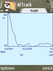 |
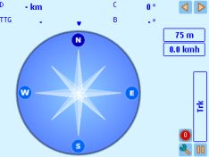
Profile
This view shows the elevation profile from your active
track.
- max. and min. altitude
- track length
- duration
- last altitude
- after normalization the rising and falling values
With up or down button the view can be switched between
high and speed values.
In 3rd edition this will be found at the track menu.
|

|
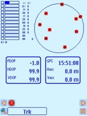
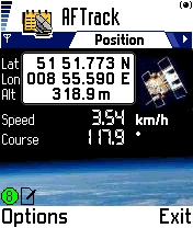
Satellite
The
view shows all visible satellites in its position and gives the
information about the level of received signal strength and which
satellites are used for
the fix. The position, horizontal and vertical dilution of
precision are also shown (PDOP, HDOP, VDOP). Last value is the altitude
correction.
In 3rd edition with more then 12 satellites when
available.
|
|
|

|
Waypoint
The waypoint information for the current point:
Short name
Little description
The bitmap with the point symbol
An indicator if a long description is available
Distance and bearing from your position
The text is stored in the AFTrack
txt directory.
|
|
Big display
The top view is changable in the display settings. For the bottom
view use the up or down button.
|
|
|
|
Menu
values
|


|
Track menu
Start Track - Toggles the flag for tracking on/off. If
the
flag is ON
the views show a log sign at the bottom.
Edit Track - Brings a dialog to edit the track name (12 characters) and
the track description (60 characters).
List Track - Shows the list of the saved tracks. The selected value is
also the current track for saving locations.
New Track - Inserts a new track when there is no running track. This
then is the current saving track.
Delete Track - Deletes the selected track. There will always be a last
track. If you want to delete all tracks to get a blank new track please
use the
menu 'Database' - 'Clear DB'.
Export Track - Exports the active track (PCX, KML, IGC or GPX format).
Track to Route - defines an old track as a new route.
The
track is lost. If the track is still needed go the way arround export
track (PCX format) and import route.
Normalize Track - The counted track values MaxAlt, MinAlt, AvgSpeed and
so on
are calculated from the GPS values which you normally receive every
second. The track values for position and time are saved in the
selected matter. The track time can be stopped. All other programs for
track interpretation will
get another result as this program shows. The other values are unknown
for it. So you can normalize your data after a track.
Database menu
Exports the complete database or let you clear all saved
dates.
GPS menu
This enables the sirf commands for power save and
additional
data
sentences (GLL, VTG). For the power save command is no answer, so when
we start the status is undefined.
'Reset GPS' brings the GPS from SIRF mode to NMEA mode.
A GPS sentence is send as SMS to the draft by pressing
the
menu entry. Send it from there.
If you running parallel to the log a HTTP report, please
activate 'Start HTTP Send'
|
|
Keyboard
The key short cuts help to get a quick access to some
features.
| > |
Moving to next view
|
<
|
Moving to next view
|
/\
|
Map scale up, waypoint up, switch to routing,
select new view in big view
|
\/
|
Map scale down, waypoint down, switch to routing,
select new view in big view
|
OK
|
Main views: Menu for a to-do list with the current
position
In lists: edit item
Calibration view: edit points
Position: edit values
send position
|
1
|
Position view (3rd Edition: position/track view)
|
2
|
GoTo view
|
3
|
Map view
|
4
|
Trip view (3rd Edition: big view)
|
5
|
Profile view
|
6
|
Satellite status view
|
7
|
Track list
|
| 8 |
Waypoint list
|
9
|
Route list
|
0
|
Map list, in map list Auto Map
|
| all
0-9 |
Send SMS (when selected in settings)
|
#
|
Map view: Toggles view between map zoom and map
move or
waypoint list and single waypoint view
Position view: Toggles displayed position format
|
*
|
Map view: Toggle between viewing map position,
track
centered or route centered
Waypoint view: gets a text if available
Calibration view: toggles between 22 points, 88 points and 1 point
moving around
|
| c |
Delete entry or delete parameter (in HTTP settings)
|
|


|
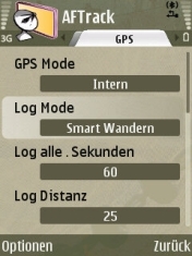
Settings
Select your configuration here. Four modes are available.
GPS mode:
- GPS Mode - select internal, external or none gps
hardware (3rd generation only)
- Log Mode - handles the different modes for logging.
- Log
Seconds - frequency for logging only used at log on second (values from
1 to 1800 seconds (30 minutes), make sure you have enough space when select 1 second
steps)
- Log Distance - log after a distance of x (in 1/1000
sm 1 sm = 1854m)
- Altitude - select meter or feet
- Speed - select knots, miles or kilometers per hour
- Position Display - shows the position format on the map or
calibration window. In 5th generation version the position format in the position editor is set in the landmark settings.
- Kalman Filter - Set the filter on/off (does a smooth
operation on the flipping values for altitude and speed)
- Logging angle - in smart logging the angle when a new
track
point is generated
- Pause on speed less - when the speed is below the
value the
program register a pause (value is in 1/1000 knots (nautical mile per
hour) e.g. 50 mean
0.050 knots)
- Altitude correction - the altitude correction (send
in the
$GPGGA sentence) is used or not
- Value for a manuel altitude correction. Some gps hardware doesn't send a value.
- On some hardware a compass is build in so you can tell the app here to use it. (not for i8910)
In 3rd or 5th edition the application needs a signed
version of the plugin to work with an internal
gps - see below.
Display mode
- Wpt Sort - How to present the waypoint lists (removed in 3rd/5th generation)
- Map Display - Waypoint are shown, with or w/o label
- Map Position Display - If set to 'on' the position is
shown
on the map
- Display on Map for various indicators (3rd/5th generation only)
- Display Map at Start - Loads a selected map direct
after
program start.
- Map
Center - The center of the map view is defined by the
position. To move around without map refresh select a value bigger than
1. This builds a square around the map center where the position
reminder is moving but not the map (values between 1 and 80 points).
- Map Show Grid - The grid on the map display is on/off
- Map Show Bearing - Offers a red line to the GoTo
waypoint
or the next routing point
- Color of Track - Sets the beauty of the track
- Color of Route - Sets the same for the route
- Line Size - Sets the thickness of the track or route
in
points
- View track as line or points
- Define the size of the position pointer
- Define the color of the position pointer
- Show Icon grid - The selection of a bitmap for the
waypoint
can be displayed as grid or icon list
- Big display selector for what will you see on top
- Background color
- Line color
- Lock Keys - Will protect your phone (this will only
work
when lights
are off)
- Close application before the battery is out
- Light always on - Holds the background light all the
time
but costs a
lot of battery power
SMS Report mode
- Log Mode - Can be off, send to the draft folder of
your
phone, send direct to the selected number or send always with a saved
track point. Be careful with this option. When you select in log mode
15 seconds the SMS could be still on your phone without sending yet.
- Report
Mode - Select what to send: GGA or RMC (both are only possible when GPS
is connected), the Live-Tracking.com format or a plain text version of
the position
- SMS number - Where to send the short message.
- SMS reason - use this only with the Live-Tracking
format
HTTP mode
- Log Mode - Select the sending features: off, manual
or
direct with a tracking point (works only if a track is running)
- Some parameter for the HTTP connection:
- Server - the server address w/o http://
- Port - used port address
- File - file on the server to read the values
- Id - the name of the identity parameter
- Id Mode - send your IMEI for identity or define
an own
value
- Id Value - the value for the id
- Password - parameter name for a password
- Password Value - the value for the password
- Latitude - name of the parameter
- Longitude - name of the parameter
- Altitude - name of the parameter
- Speed - name of the parameter (value belongs to
the
speed settings kmh, knots, mi)
- Direction - name of the parameter
- Message - name of the parameter
- Message value - a message text to send
- Proxy use and ip address
- Proxy port
The settings for the internet connect you will find in
the 'access points' dialog of the general settings. The parameter for
this entries you will get from you
carrier.
The default entries in this menu makes a connection
to http://www.whererya.com.
To define other server leave the unused parameter
blank.
E.g FindU to
get
http://www.findu.com/cgi-bin/inputpos.cgi?call=mycall&passwd=xyz&lat=12.3&lon=-12.3
fill only this
[Id] call
[Id Mode] Define
[Id Value] my2call
[Password] passwd
[Password Value] xyz
[Latitude] lat
[Longitude] lon
IGC
Settings
- Pilot name (must be filled)
- Glider type
- Glider id
- Wettkampf id
- Wettkampf class
|
 |
Waypoints
The waypoints are shown as a list or a single view. Each
of
them has a position with altitude, a bitmap for the display, an alarm
distance and an alarm function.
Alarm distance and function is set on the import and is
predefined on the used waypoint group. Same with the bitmap - if this
it not announced in the import file. E.g. a new waypoint is
added. It gets the values from its waypoint group
To add a waypoint from bearing means the start is the
current
position and you have to enter the distance (input depends on the
selected speed mode - m, ft or nm) and the angle to run.
Another option uses the current waypoint to create a new
point
via the bearing and distance.
To add a waypoint from map needs a calibrated map.
Please
enter the calibration view (see menu in map list). Select a point with
the cursor, press the enter key and select the waypoint entry.
Define a waypoint from main map:
First select a calibrated map from the map list. Press '*' until you
have the map centered and visible. Then in the waypoint menu a new
entry is shown - 'Define Waypoint'. This brings a red circle to the
screen center. Move around to find your waypoint. Than press the center
of navigation button and select 'Position as Waypoint' or 'Cancel'.
Set the current waypoint as new position - this only
works in
offline GPS mode.
A special waypoint mode is the anquer alarm. It defines
a position and when leaving an area of ~ 50 meter an alarm sounds.
|
|
Waypoint
Groups
Waypoint
groups are selections of waypoints to organize the system. Here are
placed the import and export routines for the waypoints. Please use
only geodetic
coordinates
(not UTM format) for import.
All waypoints in a group can get the definition of the
group.
|
| |
Special: Use of Areas
A group of way points can be used as an area. The
border
is made point by point in its normal order. The last point is connected
to the first point, so a final point over the first one is
not necessary. The area may defined as ToGo or NotToGo area
- this regulates the color of the area.
(3rd and 5th Generation only) sample areas CTR in Germany
|
|
|
User
defined bitmaps
The bitmaps are stored in the AFTrack
data subdirectory pics.
There is a text and a bmp file (icons.txt and icons.bmp).
To define own
pictures rename this an place a new icons.* file here.
Bitmap size is
16x16 up to 32x32 pixels for each. Use 256 colors. For a whole bitmap
you need x tiles (e.g. 160x32 for five peaces). If the background color
is white this it use as transparency. See sample in the pics directory.
Sample: 96x32

with text:
Geocache|Traditional Cache
Geocache|Multi-cache
Geocache|Unknown Cache
|
|
Sample for waypoint import
To build a nice sample for the waypoint import go to
these
address
http://www.alertegps.com/Download_index.asp?a=ar&s=
(2006-03-24)
and get the file Pcx5.wpt
with
some radar Point of Interest
To use your radar file do this:
- create a waypoint group 'radar'
- edit the group and set the alarm distance (meters)
and
sound (no sound
- no alarm)
- import the file to this wpt group
Or just use the samples files (wpt or loc) with some
waypoints.
To get text to your waypoint just place text file with
the
short name of your waypoint in the AFTrack
txt directory. E.g. for a
waypoint 'GC4711' use a text file named 'gc4711.txt'.
Geotoad
offers
to collect all informations from geocaching.com in one GPX file.
e.g.in DOS mode
c:>geotoad -f gpx -q coord "N40 45.0, E014 30.0" -y 5
gets all point inside 5 miles around the coords. The
waypoints
are
imported and from the groundspeak:long_description tag the needed text
file is saved.
All file import or export uses the directory
?:/Nokia/Others/AFTrack
|

|
Routing
A route can be generated from an old track or by using
the
import
function - this needs a PCX file from a track or a route (*.trk or
*.rte - on 3rd generation hardware you may use also *.gpx or *.kml).
Please use only files in this formats:
H IDNT LATITUDE LONGITUDE DATE TIME ...
W TR0000 N52.371971 E010.145681 18-SEP-04 09:24:17 ...
W TR0001 N52.372024 E010.019382 18-SEP-04 09:25:50 ...
W TR0002 N52.372168 E010.895003 18-SEP-04 09:27:21 ...
or
H LATITUDE LONGITUDE DATE TIME ...
T +52.371971 +010.145681 18-SEP-04 09:24:17 ...
T +52.372024 +010.019382 18-SEP-04 09:25:50 ...
T +52.372168 +010.895003 18-SEP-04 09:27:21 ...
The flags points to the end of the route. When a route
is
started and there is a nearer point than the start point the program
asks for the entry point. So it's possible to do only a part of a route.
All file import or export uses the directory
?:/Nokia/Others/AFTrack
In the version for the 3rd generation the import for GPX
tracks or routes is also available. The files are found in
?:\Data\Others\AFTrack.
|
|
Overlay import
You may import areas in the KML format
Placemark/Polygon. Default is the import as NoGo-Area (red), this may be changed to ToGo-Area or simple.
Here a sample with German air ports.
|

 |
Map support and
calibration
First load a map from a place in the phone or the memory
card.
The file is not transfered to AFTrack.
The program
only stores the map information. The maps can be in jpg, gif or bmp
format. The GPS values are use direct so the map date has to be WGS84.
The second thing is the calibration of the map. Enter
the
calibration dialog over the menu, select at least two points on the map
and define this points manually or use the current position for it. The
map is only calibrated when the 'save' menu is selected. Don't keep the
calibration point to near to each other.
A good source to solve the calibration problems is for
me the TerraServer.
The sat pictures helps to find some special calibration points and it
coordinates. Or try infosports.com a small geo coder
(25th April
2006).
For moving around in the map use the navigation button.
Switch
between 1 point or 22 point moving by pressing the * key
Notice:
Only BMP, TIF and BSB can be bigger in size then the phone memory.
Normally the
bitmap should have only 8-bit color to save space and should be with no
compression.
The
usable chart size belongs to the ram size of the phone (Nokia 3650 4MB
Ram, 6600 8 MB). A map uses this size: a Gif file
(300 KBytes file size) and 866x502 pixels uses around 900KBytes of
space in the 1:1 view. Only the bsb file needs less space - see below.
Sample Map Source: Part of the German Topographic Maps
1:50000 
Auto
calibration
The bitmap file needs a calibration file in the same
directory
and with the same name.
Supported are
- GeoTIFF
World
Files (tfw or jgw) only in geodetic coordinates (e.g.12.456, -45.123) or UTM
- OziExplorer
map
files in
geodetic coordinates
- Mapshare
gmi
files version 1, 2 and 3 (see here)
- UI-View
inf file
format
- TOP50
log file
(see German doc)
To read a tfw file in the UTM format please add the UTM zone information. Sample:

           25.0000000000
            0.0000000000
            0.0000000000
          -25.0000000000
       319462.5000000000
      6263637.5000000000
56 H
Using and making BSB maps
With this format it's possible handle maps dimensions
greater
than phone memory.
The OziExplorer is able to import this file format. A
simple
graphic viewer for BSB get here ImageVisu
(2006.02.01).
How to design a bsb file:
Download this package from libbsb.sourceforge.net
and read the description.
The bitmap must assigned as tif format and must have
less than
128 colors
You will need a template file like this, edit only the
red
part. REF are the calibration points with x,y,latitude,longitude, so
there is no separate
calibration file.:
!Handmade Meran.kaptmp
VER/2.0
BSB/NA=Meran
    RA=3693,5190,DU=254
KNP/SC=1729000,GD=WGS84,PR=MERCATOR,PP=55.00,PI=0.000,SP=,SK=0.0000000
    TA=90.0000000,UN=METERS,SD=MEAN SEA LEVEL,DX=172.90,DY=172.90
CED/SE=2000,RE=03,ED=01/01/2000
OST/1
REF/1,183,3198,46.68122,11.09301
REF/2,2208,1976,46.727896,11.20246
DTM/0,0
CPH/0
IFM/5
Call the program as: c>tif2bsb my.kapmtp my.tif
my.kap
There can be more the two calibration points. Only three
of
them are used (2 with the greates distance and one other point). Make
sure that the points are in a triangle.
When an error correction if defined in BSB header it is
used.
Only bsb3 files are available. The file extention of BSB
files
is *.kap
There is a tool that uses the BSB library and has a
graphical interface. Please try RasterChart2BSB
Here a short documentation concerning kap file generation.
Here you find some available sea maps in BSB3 format:
US area: charts.noaa.gov
Europe area: SeaNavCD (German): Baltic Sea, North Sea, Mediterranean_Sea
or SeaNavCD (English translation)
Using
GeoTiff maps
GeoTiffs
are maps
with the calibration information inside. They are usable only with
uncompressed tiff and in WGS84 coordinates (geodetic or UTM)
To
make the included
information visible use the tools from this site.
http://dl.maptools.org/dl/geotiff/libgeotiff/
more information about this format see
http://www.remotesensing.org/geotiff/geotiff.html
Using OpenStreetMap maps
Select in the map list the wms option 'OpenStreetMap'.
If
there ares no map available the bitmaps are loaded via the internet.
The cache is always in the memory card
at e:\Data\Others\AFTrack\cache\osm. Start is always zoom
level 13.
You may load maps without having internet connection via
your pc. Look for the application MobileAtlasCreator. Select the region and the zoom level you need and
start download. In the directory tile all files are stored in zoom
level directories. Copy all to the cache directory 'osm' to your memory
card.
Here other addresses for getting OSM tiles www.opentom.org, JTileDownloader
An other idea of using OSM is to tranfer it to BSB format
http://sites.google.com/site/tintenbrotproject/ttc
This application also generates GMF map format which
holds the
OSM tiles inside. This is also usable with AFTrack (up to 4096 tiles in
one file).
In ?\Data\Others\AFTrack\Pics you will find a server
config
file named 'maps.wms' (maps.txt is the default). This contains samples for the define of different
servers. Always use in the same way.
label=OpenStreetMap
host=tile.openstreetmap.org
path=/%z%/%x%/%y%.png
port=80
cache=osm
label=OSM Cloudmade
host=c.andy.sandbox.cloudmade.com
path=/tiles/cycle/%z%/%x%/%y%.png
port=80
cache=osmcloud
%z% zoom may change to %zg% to get a google zoom value.
Make sure to save this settings before install
a new version of AFTrack
Beware of deleting the cache. That take a long while and
is better done with the PC Suite.
The cache can also used only for offline. You may select this in map menu 'WMS Cache'.
OSZ Files
An other thing is holding the tiles as offline zip file.
Please insert into a zip file this format (directory for zoom
and x value) and rename it to *.osz. It is possible to add more then
one zoom level. If there is a manifest.txt file the calibration is
taken from there. Otherwise the directory structure is scanned.
Sample
manifest.txt
13/4634/2304.png
13/4634/2305.png
and so on.
Format manifest.txt
delare all zoom level and the min/max tiles of the highest level.
zoom=11
zoom=12
zoom=13
zoom=14
zoom=15
minx=18536
maxx=18567
miny=9216
maxy=9255
This kind of map can be generated with www.tintenbrot.de latest version. Also the MobileAtlasCreator generates this format (since version 1.8a7).
The file size seems to be restricted to ~100 MB - belongs to the hardware. Also jpg format is usable.
(OSM maps for 3rd or 5th Generation only)
|
|
SMS
Reports
SMS reports a send to a phone number defined in the
settings.
This sends the $GPGGA, the $GPRMC sentence or just the
position as plain
text. Select this feature in the settings for SMS.
This can be use for the reporting on live-tracking.com
Other programs can use this as input to show your
position.
This program also receive SMS report (select GGA mode)
from
other AFTrack
users and store
the incoming values as a waypoint. For the name of the waypoint the
phone book entry is used - if not already there.
For the automatic sending of a sms you'll need three
options:
a track must be running, the sms option must set to 'automatic log' and
in GPS menu the SMS sending must be activated.
|
|
HTTP
Reports
There
are several parameters to set up a HTTP connection. Select
'manual' or 'with log' as the log mode in the HTTP Report settings to
get a manual or an automatic logging. Automatic logging runs with the
frequency selected as GPS log mode. Make sure that the time for the
logging is greater than the GPRS answering time. For all other
things use the defaults to get in first contact with this features.
Than you will need a running GPRS connection. See your
manual
to
establish one.
To use this in an easy way just set log mode to 'Manual'
and
use the default values.
The correct running connection will place a position report a the
defined server www.mapserver.co.nz. To see you position online use this
page
http://www.mapserver.co.nz/aftrack/index.phtml
is deprecated.
The new address is http://www.whererya.com/
http://www.whererya.com/addposition.aspx?id=???&pass=ABCDEFG&lat=1.23&lon=4.56
is the new default. You will need you IMEI to replace
the ???.
To get the information about your IMEI send *#06#
to your
phone.
You can get your last
position with
http://www.whererya.com/data/???_ABCDEFG_latest.kml
??? your IMEI please replace
or
the history of your messages
http://www.whererya.com/data/???_ABCDEFG_history.kml
??? your IMEI please replace
Or just use the user
interface at the start page.
The logic to build is:
http://server:port/file?key=value&key=value...
Another tracking page
is MyTracking,
uses Google Earth satellite pics.
Or www.reperion.com
also has free tracking accounts.
At magnalox.net you have animated tracks and a
information how to handle the parameters.
http://forum.magnalox.net/index.php?t=msg&th=79
For aprs use (see sample in HTTP settings)
http://www.findu.com/cgi-bin/inputpos.cgi?call=callsign&passwd=abcd&lat=52.22&lon=9.44
Tracking Server - http://mlt.ath.cx
Advice see http://www.mtb-news.de/forum/showthread.php?t=440863
Testing people wanted (Jan 2010).
|

|
Log Modes
No Log
Manual
Smart for Car
Smart Boat/Bike
Smart Walking
1 to 1800 Seconds
after Distance
Long Time Tracking
direct logging
NMEA log - with external gps only
Keep in mind the logging
uses a lot of space and consums also a lot of system power. The refresh
of the GPS is mostly 1 second. So all active screens follow this
feature and refresh all seconds. That means recount the track, the
route, the map and so on.
Manual logging only logs by pressing the middle
navigation
button. This is also used in all other log modes except the log off
mode.
Direct logging writes log file direct to phone space in the
AFTrack directory. Filename is date.gps. The database is not filled, so
no track is painted.
Smart logging gives you the chance to have various
logging
times at different speeds. All values under or above the limits have
the max. or min. logging time.
Car   10 km/h - 10 Minutes, 120 km/h - 1.5 Minutes
Bike   2 km/h - 10 Minutes,  18 km/h - 1.5 Minutes
Walk   1 km/h - 10 Minutes,   5 km/h - 1.5 Minute
Or after x degree change of the corner. Select the 'log
on
angle'
value in the GPS settings - the values are possible between 5 and 35
(default 25).
Das NMEA log writes out all received sentence and doesn't save this
values in the database. So no statistic values are available.
|
| |
Special: Long Time Tracking
Long Time Tracking switches the gps modul off.
When a track is
started the gos is switched on and the user has to take the first point
manually. After this the modul is shut down again and after a definated
time the program logs in to the gps and when the signals are good a
point is taken. Switches off after this. The settings of seconds are
used as minutes now. A good gps hardware to perform this method is the
Nokia GPS-Modul LD-3W. It has a 7 days
standby time. Also the phones life time is growing up with no permanet
bluetooth signal.
|
|
|
|
Special for OpenStreetMap
OpenStreetMap is a project to collection free geographical data.
See wiki.openstreetmap.org
for more information.
AFTrack could give some small help for the collecting process.
What to do for prepare:
1. Define a list with of your favourite tags your like to collect. The
rule is each entry one line e.g.
highway
primary
secondary
cyclepath
footpath
or make it different with groups
highway=highway
highway=primary
highway=secondary
waterway=river
waterway=channel
2. Define a color for each so you can see it in different color on the
map. The rule is ';' is the separetor and the color value is
hexadecimal. Some thing like on this link en.wikipedia.org/wiki/Web_colors
highway;ff0000
primary;ff00ff
secondary;bb3333
cyclepath;bb7733
footpath;773300
3. Name this osm.txt and copy it to your AFTrack directory/pics.
AFTrack comes with one file sample.
What to do for use:
1. Select 'new Track' to define a new object
2. Select 'new waypoint group' in waypoint menue
3. Select in navigation button menue the 'OpenStreetMap' and define the
kind of track.
4. Start track.
The OSM feature is made visible by add 'OSM:' to the track name. And
the line is shown in the color of the selected kind. (At kind 'None'
the color is the standard track color selectable in the option/display
menue)
Optional:
- During the track is running the kind of track can be changed to an
other kind or to none.
- Collect also way points by pressing the navigation button.
After collecting the track can be exported to KML (included with the
defined colors) or GPX format. Both
contain the track parts and the entries in the current waypoint group.
|
|
track samples
|
Log file
The log files are saved in the \Nokia\Others\AFTrack
directory.
Log file format (PCX):
H SOFTWARE NAME & VERSION

I PCX5 2.08 by AFTrack 1.01
H R DATUM IDX DA DF ...
M G WGS 84 100 +0.000000e+00 +0.000000e+00 ...

H R DATUM
U LAT LON DEG

H TRACK SUMMARY
H Track Pnts Date Time Duration
H TN Trk1 126 07-04-04 11:15:29 01:13:20 Track 1

H LATITUDE LONGITUDE DATE TIME ALT
T +44.1234567 +009.0000000 07-APR-04 10:15:21 27
T ...
Use this format to get a chart view from your tracks at GPS
Visualizer
(nice SVG
output) or with other programs.
In UTM notation the export is done in UTM format.
H  ZONE EASTING   NORTHING  DATE      TIME     ALT
T  32U  556080.2  5793195.9 31-Mrz-05 17:41:49 65
Use other options of translation with GPS
Babel
or other programs like this.
A newer option is the export into the IGC, GPX or KML
format.
In IGC log file this software is registered for glider constests at http://www.onlinecontest.org/
IGC has a
security line for all point lines and it can be verified with a
separate tool that the log was not changed after export. Use in DOS
mode:
c:>vali-aft mytrack.igc
Get the validate program here
|
|
Problems
Please notice always the
bluetooth sign in top of the most windows.
When the
connection to the GPS is lost a message will remind you and you have to
reconnect. Since version 1.01 reconnect works automatically. After 5
minutes this feature is stopped to save the battery.
When there is a problem with the phone - e.g. you have
to
reboot it - just start AFTrack
again and select the used track. All
tracks are saved in time and you can add new positions. May be you have
to normalize the track before continue the track.
When you are in an area with
lower GSM signals the phone is scanning for gsm cells. This
costs a lot of battery power and computing power as well. So I use an
old SIMM card. It doesn't looks for cells and this will give longer
tracks. But no calls.
The T-Mobile-Navigate-GPS only send RMC (Recommended
Minimum
Specific Data) so there is no information about the altitude and the
used satellites. See www.martin-dehler.de/gps/navigate.htm
for a detailed information (German).
BT-338 and may be other gps has a static navigation mode
which makes problems for slower moving see this for more detail and the
how to
http://www.gpspassion.com/forumsen/topic.asp?TOPIC_ID=25575
On other hardware with moving problems use the pause speed value in the
settings.
Big
XML files are sometimes a problem. The parsing is completely done in
the phone RAM. A work around for GPX files comes from Philippe
K�chler for PC and MacOS (see below). The points are bundled
to
smaller packages.
A strong use of the hardware brings a disconnecting from
the gps every few minutes.
What to do:
- Make sure there are no other programs running
- Switch the update frequency of the gps to one per
second - if it send in a higher speed
- Set logmode to 'smart' (only during tracking)
- Set the map center to a value between 60-80 (normaly
the position is map centered, so it moves at bit)
- Use BSB as map format - a little bit harder to handle
but more effective
- Use smaller maps
On Nokia N70 the dialog box for waypoints doesn't show
the
labels (better with OS update).
The N70 also has problems with sending SMS.
This program is tested only with the 6600/6630
and
GPS
Holux GR-230/BT-338.
Please report other constellations.
Nokia N-Gage and GlobalSat BT308 Bluetooth GPS
Nokia 6600 with GPSmart - BT by Fortuna
Nokia 6600 and Teletype GPS
Siemens SX1
with Fortuna Clip-On Bluetooth GPS Maus
Nokia 6600 and T-Mobile-Navigate-Receiver
Nokia 6600 and RoyalTeck RBT-100
Siemens SX1
and Falcom Navi1 Bluetooth
Nokia
6600 and TomTom
Wireless GPS Modul
Nokia 6600 and Navman 4400 GPS
Nokia 6620 and a Fortuna Clip-On Bluetooth GPS
Nokia 6600 and Micronet bluetooth GPS
Siemens
SX1 and Leadtek 9537 Bluetooth GPS
Nokia 6600 and BT-GPS Leadtek
9537
Nokia 6630 and Holux 230
Panasonic X700 and XAiOX Wonde-X
Nokia 6680 and Garmin GPS 10
Nokia 6600 and Globalsat bt308
Nokia 6600 and Falcom Navi1 Bluetooth (Mobilcom Label)
Siemens SX1 and Navilock BT 338
Nokia 6260 and Royaltek RBT-1000 (XTRAC2
Version)
Nokia 6260 and Aktronix GPS
Nokia 6630 and Xaiox Wonde XL Bluetooth
Nokia 6260 and Evermore BT-R500
N-Gage QD with SysOnChip SIRF III GPS mouse
Nokia 3230 and GPS MKII receiver
Nokia 6630 and QStarZ BT
Nokia 6260 and Earthmate Blue Logger GPS
Nokia 6670 and Haicom HI-406BT GPS
Nokia N90 with Nokia LD-1w mouse
Nokia 6630 and Navilock BT-308
Nokia 6630 and Haicom 406 BT GPS
N-Gage QD and Xiaox NaveOne BT Maus
Nokia N70 and GPSmart BT or Tomtom Wireless GPS
Nokia 6680 and Bluei GPS
Nokia 6600 and EMTAC bluetooth GPS (BTGPS III)
Nokia Ngage with FTech Solar BT GPS
Nokia 7610 and Holux GPSlim236
Nokia 3650 and Adapt AD-500 GPS
Nokia 6260 and Rikaline Bluetooth model LR9537 GPS receiver
Siemens SX1 and RoyalTek RBT 2001 Sirf3
Nokia 3650 and Mainnav MG-910 BT GPS
Nokia 6630 with QStarZ
BT
Nokia 6670 and Royaltek RBT-1000
Sendo X and Klicktel GPS
List of hardware with problems in bluetooth connection:
6630 and Holux GPSlim236 (There is a report for that: they can be
solved with a NOKIA firmware upgrade, free at NOKIA website. The
latest firmware solves several Bluetooth issues, check it at:
http://newlc.com/Nokia-Series-60-Firmware-History.html)
N70 and Holux 236 with Sirf 3
Please try you GPS with the trial version first.
|
|
AFTrack and 2nd Generation of S60
History
- Version 1.22 - Jan 2009
- new calibration logic for mpr files
- OSM GPX review
- add Ellipsoidal height if present
- bsb maps correction repair
- Version 1.21 - Oct 2008
- repair GPX export problem
- Set time from GPS
- long time tracking mode
- http mode: key value can be longer then 16 character (64)
- qpe calibration file format
- mpr Top50 map files
- Anchor alarm
- support for GLONASS satellites
- Version 1.20 - December 2007
- close on low battery
- add time stamp on GPX export
- add gps log after a defined distance
- add search field in waypoint list
- add cal (TTQV) calibration file format
- define a waypoint from main map
- Version 1.19 - September 2007
- repair proxy problem
- repair manually calibration
- set http values for alt, speed and course to integer values
- make visible/unvisible of waypoint groups
- use filename for imported routes
- added profile for the speed
- add kal format as calibration file (GlopusMapManager)
- add GPX format for track export
- add OpenStreetMap functions
- 1.18 - June 2007
- refresh KML export, start and end point, coordinates
- add 'show waypoints' in way point menue
- bring waypoint group to route
- 3 different pointer for the position (small, big, sailing pointer)
- 1.17 - March 2007
- add timestamp for kml format
- changed default url for http transfer
- new gmi format for more than 2 calibration points
- new kml overlay as calibration file
- set position from waypoint with altitude
- use automatic map selection from position
- select storage before save tracks
- import function with directory selection first
- delete all maps
- load all maps from directory
- new big view for waypoint distance, bearing, cross track error (XTE)
- 1.16 - August 2006
- GeoTiff with WGS84 or UTM calibration
- tfw files with UTM coordinates and UTM zone accepted
- BSB chart can have more than 2 calibration points
- BSB with error correction if defined in BSB header
- for BSB 3 calibration points are used
- Tiff format 1,4,8,24 no compression for maps bigger then memory
- Bmp format 1,4,8,24 no compression for maps bigger then memory
- calibration view '*' switch to 1,22,88,1,... points to move
- import waypoints from KML format
- enable SMS report for live-tracking.com
- add altitude for gpx files
- repair goto from waypoint screen
- repair big display for altitude
- NMEA checksum test (on/off)
- 1.15 - April 2006
- Export tracks to KML format (viewable with Google Earth)
- Export waypoint group as KML format
- Text SMS contains selected position format
- push up the timeout for the first http connection
- add new option in display settings: view track as line or points -
for a better view in
static mode
- add max speed control for normalizing a track
- add a speed parameter for the http connection
- add angle to next route point
- add menu button to next route point
- add big display for some output values
- add settings menu for IGC export
- add SMS feature 'send on any key'
- changed validation program (vali-xft.exe)
- repair: map rename
- 1.14 - December 2005
- support for bsb files
- show map on start
- proxy settings for http
- 1.13 - September 2005
- repair xml import
- smarter zoom function
- short cut for map list (0)
- '8' toggles between waypoint list and waypoint group list
- add waypoint entry from current waypoint bearing
- set current waypoint as position (offline mode)
- 1.12 - September 2005
- add waypoint entry from bearing
- add new waypoint from calibrated map
- send also GPRMC sentence via SMS
- send position as readable text via SMS
- use gmi file format version 2.0 for calibration
- use UI-View inf file format for calibration
- logging angle for smart logging is editable (5 to 35 degree)
- pause by speed less than (in 1/1000 nm)
- altitude correction selectable
- NMEA direct log
- 1.11 - June 2005
- automatic calibration with TOP50 log file
- also tfw or jgw file format with geodetic values (no tiff support)
- also OziExplorer map files
- also gmi files
- edit map name
- edit position in the selected output format
- 1.10 - Junu 2005
- add mapping
- add loading maps from jpg, gif or bmp file.
- calibrate the maps on board
- scale the maps until no more memory or to small
- add waypoint group setting for all members
- free logging interval
- set map view between goto and trip view
- icon in map refresh after changing
- 1.09 - April 2005
- add variable format on position view
(UTM, DD.DD, DD MM.MM, DD MM SS.SS)
- add position display in map view
- add export for IGC file format with security record to test the
integrity of the log file
- 1.08 - February 2005
- save last track point
- add routing
- add making route from track
- routing import from as PCX
- the waypoint view is added
- copy the current position into the clipboard
- feature for geotoad: make text file from groundspeak:long_description
- add Italian and Dutch
- 1.07 - December 2004
- Waypoint import from GPX file format
- 1.06 - November 2004
- Waypoint import from LOC file (Geocaching XML)
- Text files for a bigger description of a waypoint e.g. Geocaching
find rules
- 1.05 - November 2004
- German version
- Fix a problem with the Telekom Navigate GPS
- 1.04 - November 2004
- HTTP parameter handling (delete value on key 'c')
- Alarm also on reached POIs
- 1.03 - October 2004
- New menu: Waypoint
- Save position as waypoint
- List waypoint (all)
- Edit active waypoint
- Select waypoint group
- List of waypoints in the group
- Import waypoints for the group
- Export waypoints for the group
- Export all waypoints
- HTTP position sending
- SMS position sending
- SMS position receiving
- New settings menu
- 1.02 - September 2004
- Bugfix South-West problem
- Added a map view.
- The keys '1' to '6' reaches one of the six views
- A GPS sentence is send as SMS to the draft
- Reset GPS from SIRF to NMEA
- Automatic reconnection to GPS if connection lost
- Stop reconnection if not necessary
- Filter the altitude value with a Kalman filter
- Manual logging
- 1.00 - June 2004
Initial program start
|
Note:
only 2nd generation,
not usable on a 3rd
or 5th
generation Symbian phone (E60, E61, ...)
Trial
SIS download
English (351k) or
Trial SIS download
English,
Deutsch, Italian, Dutch, Spanish (381k)
zip download (1045k)
buy at Handango
Get the validation for IGC format program
(Dos 52K)
A tool for GPX cache files splitting by Philippe
K�chler
AFTrack
Assistant_1_0_0.zip
AFTrack description as PDF
Trial
version exports only 3 points, only 3 maps, send HTTP reports only
manually,
send SMS reports only to draft folder and it is time limited.
|
|
|
Sample Map Source: Part of the German Topographic Maps
1:50000
AFTrack and 3rd Generation of S60
The version for the 3rd generation has the nearly the
same features
as the current version.
It only differs a little bit in the screen design. The
main and track view comes now in one screen. The
profile
screen is moved to the track menue and the waypoint view to the
waypoint menue. The new generation also has better xml support.
The new path for saving is c:/Data/Others/AFTrack or
e:/Data/Others/AFTrack
Comparing internal and external gps runtime (gsm
offline, 10s per point):
N95 internal ~7.5 h
N95 external ~16 h
This software is not Symbian signed. So you have to
switch the application manager settings 'Software
installation' to 'All'.
Note:
An external GPS receiver is needed. See below.
Tested with Nokia E60/E61/N95 and BT-338 or
XaioX
InstantFix
Problems are reported for
N73: GPS user report - "Updating the firmware worked
like a charm. No
drops in bluetooth connection.
Here is a link on N73 firmware http://www.allaboutsymbian.com/forum/showthread.php?t=51669"
E62: logging problem with GPSSlim240
Version 1.13 - April 2013
- TK102 clones, Xexun TK102B
- GPS Tracker 2 dnt
- TK102-2 Update
- SMS template repair
Version 1.12 - April 2012
- kml map calibration relaunch
- lock display complete
- add geo id for internal gps
- add 640 x 480 screen size
- add sms send template
- add zoom levels for gmf map files (GlopusMapManager exports)
- add GPS-Tracker ELRO support
Version 1.11 - April 2011
- save zoom level and start with it
- enable saving when WebDAV is present (but not saving on it)
- enable saving on USB host
- unvisible for overlays
- change way point entry view
- problem map sort fixed
- compass for position pointer enabled
- add speed format m/s, min/km, min/mi
- add switch UTC/local time
- add way point label with time
- add sms receiver for GPS tracker TK 102-2
Version 1.10 - Dec 2010
- SMS bug on position report
- load directory bug
- add wpt edit dialog after insert for fast editing
- more than two drives accessable - if available
- enable osz files with jpg bitmaps
- enable utm in map (ozi) calibration files
- fix refresh display without active map
- add the second name of the way point in map display
- bug export gpx waypoints fixed
- Switch 'never go online'
- Color selector for map pointer
- fix position editor for E72 or so
- no own text saving on import when SmartGPX on board
Version 1.09 - Mar 2010
- three options for map on start
- route restart in main menu
- altitude correction also for bt gps without correction
- change map file format to enable other systems
- add zip map file for OSM tiles (osz)
- add overlays for area data (kml format)
- add center on goto waypoint
- add big sign for waypoints - shows alarm distance around point
- new compass view with graphical index for XTE
- repair way point view on E71
Version 1.08 - Nov 2009
- T9 in name dialog track or route
- auto map shows now the best scaled map on position
- call SmartGPX with current way point
- track name generation changed to date/time
- at waypoint distance alarm 0.0 the GoTo mode never ends
- hidden directory for cache on OSM
- gmf map file format
- log time up to 30 minutes
- repair keyboard problem on E55 for * and #
- display gps time at phone zone
Version 1.07 - July 2009
- Download rate displayed
- OSM map server define
- Transparency for way point icons on white color (see samples in Pics
directory)
- add VMG (Velocity made good)
- add OVL track export
- new menu structure
- lines thickness up to 5 points
- set time from gps is moved to the plugin (please use plugin 1.2 now)
- add French, Swedish, Finnish
Version 1.06 - Jan 2009
- repair http report for German users
- define colors for background and lines
- OSM refresh mode, reloads only viewed maps to cache
- new calibration logic for mpr files
- OSM GPX review
- add Ellipsoidal height from $PTNL,GGK - if present
- modify sat view layout, add alt correction and quality indicator
- BSB maps correction repair (French sea maps)
- new icons
- sort moved to list menu
- set time from gps is moved to the plugin (please use plugin 1.1 now)
Version 1.05 - Oct 2008
- repair GPX export problem
- Set time from GPS
- long time tracking mode
- http mode: key value can be longer then 16 character (64)
- qpe calibration file format
- mpr Top50 map files
- Anchor alarm
- add support for GLONASS satellites (extern gps only)
- add split routes import in GPX
- opencaching.de tags used
- make waypoint groups to areas
- alarm sound used for waypoint reaching
- moving on the map works also on auto map
- gpx waypoint export
- using OpenStreetMap
- internal gps
Version 1.04 - December 2007
- close on low battery, battery low dialog
- add timestamp on GPX export
- add gps log after a defined distance
- repair sms text coord
- repair route compass on 5500
- GPX import with more groundspeak features
- profile for height also from route
- route import with altitude
- add search field in waypoint list
- add cal (TTQV) calibration file format
- define a waypoint from main map
Version 1.03 - September 2007
- repair proxy problem
- make visible/unvisible of waypoint groups
- use filename for imported routes
- added profile for the speed
- add kal format as calibration file (GlopusMapManager)
- add GPX format for track export
- add GPX format for route import
- add OpenStreetMap functions
Version 1.02 - June 2007
- short keys for E61 also with letters
- compass problem on E61, E70, N95 fixed
- repair http send problem on German phones
- refresh KML export, start and end point, coordinates
- add 'show waypoints' in way point menue
- again: AFTrack directory changed ?:/data/others/AFTrack
- bring waypoint group to route
- 3 different pointer for the position
- Rotate screen in option menu (not for E61)
Version 1.01 - Mar 2007
- changed default url for http transfer
- new gmi format for more than 2 calibration points
- new kml overlay as calibration file
- set position from waypoint with altitude
- use automatic map selection from position
- select storage before save tracks
- import function with directory selection first
- delete all maps
- load all maps from directory
- new big view for waypoint distance, bearing, cross
track error (XTE)
- repair automatic http position reporting
- repair black numbers in big view on N73
- work around for compass problem on N80
- use new xml routine for gpx import
- some smaller problems fixed
- switch the directory for a phone installation to
c:/data/others/AFTrack
Version 1.0 - January 2007
|
|
|
Note: only for 3rd generation,
not usable on
a 2nd
or 5th
generation Symbian phone (like N97, 5800, ...)
Demo SIS
OS
9.1 English,
Deutsch, Italian, Dutch, Spanish, Finnish, Swedish (916k) - not using internal
gps
buy it at SmartSym - contains a signed plugin
|
|
|
|
 |

AFTrack and 5th Generation of S60
There also is a version for the 5th generation.
Sample Map Source: Part of the German Topographic Maps
1:200000
There are no short cuts available.
But the touch screen enables some new features.
| map |
- every movement on the map move it to a new
location
- a long tap on a point centers the map a this point
- a short tap on a way point opens a small menu |
other
views |
- move left /
right selects the next view
- move up / down gives more data in view - if present |
| toolbar |
each button
has its function |
Version 1.07 - April 2013
- TK102 clones, Xexun TK102B
- GPS Tracker 2 dnt
- TK102-2 Update
- SMS template repair
Version 1.07 - April 2013
- TK102 clones, Xexun TK102B
- GPS Tracker 2 dnt
- TK102-2 Update
- SMS template repair
Version 1.07 - April 2013
- TK102 clones, Xexun TK102B
- GPS Tracker 2 dnt
- TK102-2 Update
- SMS template repair
Version 1.06 - April 2012
- kml map calibration relaunch
- lock display complete
- add geo id for internal gps
- add 640 x 480 screen size
- add sms send template
- add zoom levels for gmf map files (GlopusMapManager exports)
- add GPS-Tracker ELRO support
Version 1.05 - April 2011
- save zoom level and start with it
- enable saving when WebDAV is present (but not saving on it)
- enable saving on USB host
- unvisible for overlays
- change way point entry view
- problem map sort fixed
- compass for position pointer enabled
- add speed format m/s, min/km, min/mi
- add switch UTC/local time
- add way point label with time
- add sms receiver for GPS tracker TK 102-2
Version 1.04 - Dec 2010
- SMS bug on position report
- load directory bug
- add wpt edit dialog after insert for fast editing
- more than two drives accessable - if available
- enable osz files with jpg bitmaps
- enable utm in map (ozi) calibration files
- fix refresh display without active map
- add the second name of the way point in map display
- bug export gpx waypoints fixed
- Switch 'never go online'
- Color selector for map pointer
- no own text saving on GPX import when SmartGPX on board
- edit waypoint position on touchscreen bug, using system dialog (settings on landmark info)
- same for calibration view
- more sensitive for tapping a way point
- enable cache on drive f: for some hardware
- screen rotation switch on/off
- screen lock (on map view)
Version 1.03 - Mar 2010
- three options for map on start
- route restart in main menu
- altitude correction also for bt gps without correction
- change map file format to enable other systems
- add zip map file for OSM tiles (osz)
- add overlays for area data
- add center on goto waypoint
- add big sign for waypoints - shows alarm distance around point
Version 1.02 - Nov 2009
- T9 in name dialog track or route
- auto map shows now the best scaled map on position
- call SmartGPX with current way point
- track name generation changed to date/time
- at waypoint distance alarm 0.0 the GoTo mode never ends
- hidden directory for cache on OSM
- gmf map file format
- log time up to 30 minutes
Version 1.01 - July 2009
- Download rate displayed
- OSM map server define
- Transparency for way point icons on white color (see samples in Pics
directory)
- add VMG (Velocity made good)
- add OVL track export
- new menu structure
- lines thickness up to 5 points
- repair: set time from gps is moved to the plugin (please use plugin
1.2 now)
- repair: calibration view
- add French, Swedish, Finnish
- add a little more time for tap delay on touch screen
Version 1.00 - January 2009
- same function then the version for the 3rd generation
|
|
Note: only 5th generation and Symbian^3,
not usable on
a 2nd
or 3rd
generation Symbian phone (like 6600, 6630, N95, ...)
Demo SIS
OS
9.4 English,
Deutsch, Italian, Dutch, Spanish, Finnish, Swedish (854k) - not using internal
gps
buy it at SmartSym - contains a signed plugin
|
|
|
| |
some other software |
Java:
JDBC/HTML/XML
|
dispServ
| Sailing
| search
| VRML
Pilot: Astronavigation
|
MorseTrainer
| Satellite
| TTMobil
| XMLTree
SymbianOS: Sun Compass
|
TimeTrack
| CellTrack
|
|